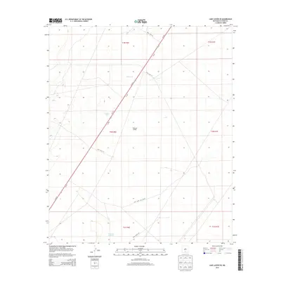
2013 Map of Lake Lucero SE
USGS Topo · Published 2013About this map
White Sands Missile Range dominates this portion of the New Mexico landscape, illustrating the intersection of military infrastructure and the arid environment of the Tularosa Valley. The map detail focuses on the managed water resources essential for operations and livestock in this dry corridor, including Tompson Reservoir, Burch Tank, and Dousette Tank. A network of specialized military access roads, such as WSMR S Route 264 and WSMR S Route 1570, crisscross the basin, providing a record of the high-desert logistical routes used in the early 21st century. The geography is largely defined by wide open flats and the strategic transportation artery of Us-70 W, which cuts diagonally across the township and range divisions.
Find a feature on this map
18 named features on this map. Tap any name to fly to it.
Don’t see what you’re looking for? This feature index may not catch every label — zoom into the map to look around manually.
Map Details
Editions of this 2013 Lake Lucero SE Map
This is the sole edition of this map. No revisions or reprints were ever made.
Other maps of this area

1916 · Point Of Sands
USGS Topo · 1:125,000

1940 · Orogrande
USGS Topo · 1:62,500

1943 · Parker Lake
USGS Topo · 1:62,500

1943 · Orogrande
USGS Topo · 1:62,500

1947 · Lake Lucero
USGS Topo · 1:62,500

1948 · Elephant Mountain
USGS Topo · 1:24,000
1948 · Parker Lake NE
USGS Topo · 1:24,000

1948 · Tres Hermanos
USGS Topo · 1:62,500

1948 · Lake Lucero
USGS Topo · 1:24,000

1948 · Lake Lucero SW
USGS Topo · 1:24,000