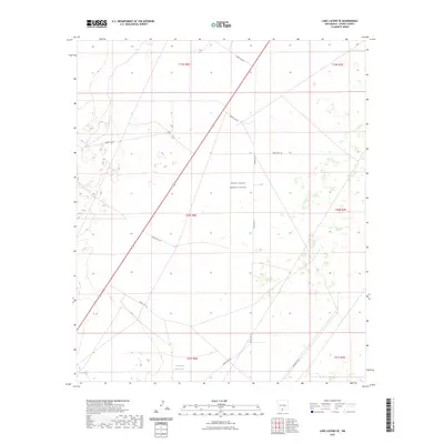
2023 Map of Lake Lucero SE
USGS Topo · Published 2023About this map
White Sands Missile Range dominates this landscape in Otero County, where military infrastructure meets the arid geography of southern New Mexico. The map details a complex network of restricted access roads, including Wsmr S Rt 254 and Wsmr S Rt 250, which crisscross the desert basin. A single notable water feature, Tompson Reservoir, appears in the southern portion of the sheet near the junction of Wsmr S Rt 3570. The grid of township and range lines provides a precise framework for this high-security zone, illustrating how the modern Department of Defense mission has shaped the utilization of these public lands. The lack of traditional civilian settlements highlights the region's specialized role as a testing and research facility.
Find a feature on this map
18 named features on this map. Tap any name to fly to it.
Don’t see what you’re looking for? This feature index may not catch every label — zoom into the map to look around manually.
Map Details
Editions of this 2023 Lake Lucero SE Map
This is the sole edition of this map. No revisions or reprints were ever made.
Other maps of this area

1916 · Point Of Sands
USGS Topo · 1:125,000

1940 · Orogrande
USGS Topo · 1:62,500

1943 · Parker Lake
USGS Topo · 1:62,500

1943 · Orogrande
USGS Topo · 1:62,500

1947 · Lake Lucero
USGS Topo · 1:62,500

1948 · Elephant Mountain
USGS Topo · 1:24,000
1948 · Parker Lake NE
USGS Topo · 1:24,000

1948 · Tres Hermanos
USGS Topo · 1:62,500

1948 · Lake Lucero
USGS Topo · 1:24,000

1948 · Lake Lucero SW
USGS Topo · 1:24,000