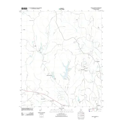
2011 Map of Lake Lurleen
USGS Topo · Published 2011About this map
Lake Lurleen State Park and the surrounding woodlands of Tuscaloosa County define this landscape as it appeared in the early 21st century. The map centers on the impoundments of Lake Lurleen and Lake Arnedra, where engineering features like the Lake Lurleen Dam and Lake Anedra Dam have transformed the local drainage of Big Creek. This era shows a mix of recreational land use and expanding residential clusters, with developments like the Arnedra Subdivision, Western Hills, and Westhill pushing into the forested terrain.
Find a feature on this map
98 named features on this map. Tap any name to fly to it.
Don’t see what you’re looking for? This feature index may not catch every label — zoom into the map to look around manually.
Map Details
Editions of this 2011 Lake Lurleen Map
This is the sole edition of this map. No revisions or reprints were ever made.
Other maps of this area

1924 · Tuscaloosa
USGS Topo · 1:62,500

1926 · Samantha
USGS Topo · 1:48,000

1926 · Tuscaloosa
USGS Topo · 1:62,500

1928 · Samantha
USGS Topo · 1:62,500

1953 · Birmingham
USGS Topo · 1:250,000

1956 · Birmingham
USGS Topo · 1:250,000

1957 · Birmingham
USGS Topo · 1:250,000

1967 · Brownville
USGS Topo · 1:24,000

1967 · Elrod
USGS Topo · 1:24,000
1969 · Coker
USGS Topo · 1:24,000