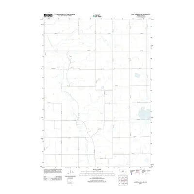
2012 Map of Lake Madison SW
USGS Topo · Published 2012About this map
The E Fork Vermillion River winds through this section of McCook County, defining the agricultural rhythm of Richland Township. The landscape is a textbook example of the Public Land Survey System, with a rigid grid of section-line roads like 243rd St and 450th Ave crossing the prairie. For genealogists, the map identifies local burial sites including Pioneer Cem located near the river and Ramsey Cem further west, both of which serve as landmarks for the early settlement of the region.
Find a feature on this map
23 named features on this map. Tap any name to fly to it.
Don’t see what you’re looking for? This feature index may not catch every label — zoom into the map to look around manually.
Map Details
Editions of this 2012 Lake Madison SW Map
This is the sole edition of this map. No revisions or reprints were ever made.
Other maps of this area

1955 · Sioux Falls
USGS Topo · 1:250,000

1958 · Sioux Falls
USGS Topo · 1:250,000

1964 · Montrose
USGS Topo · 1:24,000

1964 · Salem NE
USGS Topo · 1:24,000

1964 · Humboldt
USGS Topo · 1:24,000

1968 · Lake Madison
USGS Topo · 1:24,000
1968 · Buffalo Trading Post
USGS Topo · 1:24,000

1968 · Lake Madison SW
USGS Topo · 1:24,000

1968 · Lake Herman
USGS Topo · 1:24,000
1971 · Winfred
USGS Topo · 1:24,000
Featured Places
- Richland Township, SD
- Montrose Township, SD
- Clear Lake Township, SD
- Clarno Township, SD
- Orland Township, SD