
1964 Map of Salem NE
USGS Topo · Published 1966About this map
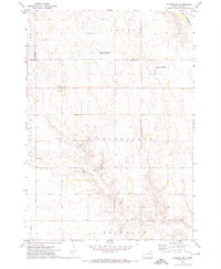
The rural landscape of McCook County is defined here by the diagonal path of the Chicago And North Western railroad, which cuts through the agricultural townships of Richland, Salem, Emery, and Canistota. Surveyed in the early 1960s, the map illustrates a transition in South Dakota's transportation infrastructure, where a major two-lane highway corridor begins to dominate the central sections, contrasting with the older rail-oriented development. Evidence of the region's historical commitment to local education is visible in the distribution of rural schoolhouses, including School No 4 in the north, School No 3 near the center, and School No 10 to the southeast. These small landmarks, along with a dense network of unimproved roads and section lines, provide a clear view of the mid-century settlement patterns in this prairie region.
Find a feature on this map
8 named features on this map. Tap any name to fly to it.
Don’t see what you’re looking for? This feature index may not catch every label — zoom into the map to look around manually.
Map Details
Editions of this 1964 Salem NE Map
This is the sole edition of this map. No revisions or reprints were ever made.
Other maps of this area

1955 · Sioux Falls
USGS Topo · 1:250,000

1958 · Sioux Falls
USGS Topo · 1:250,000

1964 · Montrose
USGS Topo · 1:24,000

1964 · Canistota
USGS Topo · 1:24,000

1964 · Salem
USGS Topo · 1:24,000

1964 · Bridgewater East
USGS Topo · 1:24,000

1964 · East Vermillion Lake
USGS Topo · 1:24,000

1968 · Lake Madison SW
USGS Topo · 1:24,000

1971 · Unityville
USGS Topo · 1:24,000
1971 · Winfred SE
USGS Topo · 1:24,000