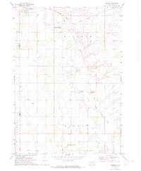
1971 Map of Winfred
USGS Topo · Published 1974About this map
The settlement of Winfred sits in the northwest corner of this Lake County landscape, serving as a focal point along the Chicago Milwaukee St Paul and Pacific railroad. This early 1970s survey captures a rural environment defined by the winding course of the East Fork Vermillion River, which snakes through the townships of Winfred, Clarno, and Vermillion. To the south of the river, Graceville Colony stands out as a distinct communal settlement pattern, contrasted by the surrounding grid of section roads and scattered agricultural landmarks like the local Townhall. Conservation efforts are evident in multiple designated National Waterfowl Production Area zones, while the presence of Gravel Pits and the Township Cem provide specific points of interest for genealogists and local historians tracking the physical development of the county.
Find a feature on this map
15 named features on this map. Tap any name to fly to it.
Don’t see what you’re looking for? This feature index may not catch every label — zoom into the map to look around manually.
Map Details
Editions of this 1971 Winfred Map
This is the sole edition of this map. No revisions or reprints were ever made.
Other maps of this area

1953 · Watertown
USGS Topo · 1:250,000

1955 · Sioux Falls
USGS Topo · 1:250,000

1958 · Sioux Falls
USGS Topo · 1:250,000

1958 · Watertown
USGS Topo · 1:250,000

1968 · Oldham SW
USGS Topo · 1:24,000

1968 · Ramona
USGS Topo · 1:24,000

1968 · Lake Madison SW
USGS Topo · 1:24,000

1968 · Lake Herman
USGS Topo · 1:24,000

1968 · Oldham SE
USGS Topo · 1:24,000
1971 · Canova East
USGS Topo · 1:24,000
Featured Places
- Winfred, SD
- Vermillion Township, SD
- Clearwater Township, SD
- Gracevale Hutterite Colony, SD
- Clarno Township, SD