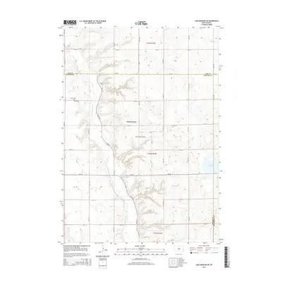
2015 Map of Lake Madison SW
USGS Topo · Published 2015About this map
Coteau des Prairies defines the rolling upland character of this South Dakota landscape, where the E Fork Vermillion River carves a winding path through the western half of the quadrangle. The terrain is marked by the distinct settlement of the Orland Colony, situated near the intersection of 246th St and 451st Ave. This area of eastern McCook County maintains a rural agricultural structure, preserved here in the early 21st century. Genealogists and local historians can locate early burial sites such as Pioneer Cem and Ramsey Cem, both located along the river's eastern breaks. To the east, the landscape transitions toward Island Lake and the headwaters of N Buffalo Cr, illustrating the complex glacial drainage patterns typical of this highland region.
Find a feature on this map
29 named features on this map. Tap any name to fly to it.
Don’t see what you’re looking for? This feature index may not catch every label — zoom into the map to look around manually.
Map Details
Editions of this 2015 Lake Madison SW Map
This is the sole edition of this map. No revisions or reprints were ever made.
Other maps of this area

1955 · Sioux Falls
USGS Topo · 1:250,000

1958 · Sioux Falls
USGS Topo · 1:250,000

1964 · Montrose
USGS Topo · 1:24,000

1964 · Salem NE
USGS Topo · 1:24,000

1964 · Humboldt
USGS Topo · 1:24,000

1968 · Lake Madison
USGS Topo · 1:24,000
1968 · Buffalo Trading Post
USGS Topo · 1:24,000

1968 · Lake Madison SW
USGS Topo · 1:24,000

1968 · Lake Herman
USGS Topo · 1:24,000
1971 · Winfred
USGS Topo · 1:24,000
Featured Places
- Richland Township, SD
- Montrose Township, SD
- Clear Lake Township, SD
- Clarno Township, SD
- Orland Township, SD