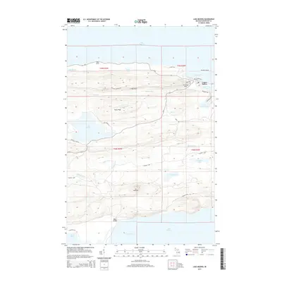
2014 Map of Lake Medora
USGS Topo · Published 2014About this map
Copper Harbor serves as the northern focal point of this Keweenaw Peninsula survey, situated where the shore of Lake Superior meets the elevated terrain of Brockway Nose and West Bluff. The settlement's history is reflected in landmarks like the Copper Harbor Cem and the nearby waters of Lake Fanny Hooe. To the south, the landscape is defined by the high elevations of Rocky Ridge and Mt Houghton, with the substantial Lake Medora feeding the Medora River. This interior region is crossed by the winding S Mandan Loop and Washington Mine Rd, hinting at the area's industrial legacy. The map concludes at the southern shore where Bete Grise sits along the protected waters of Bete Grise Bay, adjacent to Lac La Belle.
Find a feature on this map
43 named features on this map. Tap any name to fly to it.
Don’t see what you’re looking for? This feature index may not catch every label — zoom into the map to look around manually.
Map Details
Editions of this 2014 Lake Medora Map
This is the sole edition of this map. No revisions or reprints were ever made.
Other maps of this area

1927 · Point Isabelle
USGS Topo · 1:31,680

1938 · Delaware
USGS Topo · 1:31,680

1939 · Deer Lake
USGS Topo · 1:31,680

1939 · Delaware
USGS Topo · 1:31,680

1940 · Deer Lake
USGS Topo · 1:31,680

1940 · Fort Wilkins
USGS Topo · 1:31,680

1940 · Lake Medora
USGS Topo · 1:31,680
1948 · Delaware
USGS Topo · 1:24,000
1948 · Lake Medora
USGS Topo · 1:24,000

1948 · Fort Wilkins
USGS Topo · 1:24,000