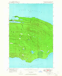
1948 Map of Fort Wilkins
USGS Topo · Published 1964About this map
Fort Wilkins State Park anchors this coastal survey, preserving the grounds of Old Fort Wilkins between the shores of Lake Superior and Lake Fanny Hooe. The landscape is a study in the northern Michigan copper boom's physical legacy, marked by a Copper Mine (Abandoned) positioned deep in the interior south of Copper Harbor.
Find a feature on this map
27 named features on this map. Tap any name to fly to it.
Don’t see what you’re looking for? This feature index may not catch every label — zoom into the map to look around manually.
Map Details
Editions of this 1948 Fort Wilkins Map
3 editions found
Historical Maps of Grant Township Through Time
200 maps found

1895 Passage Island
Keweenaw County, MI

1927 Point Isabelle
Keweenaw County, MI

1938 Bruneau Creek
Keweenaw County, MI

1938 Delaware
Keweenaw County, MI

1938 Gay
Keweenaw County, MI

1939 Deer Lake
Keweenaw County, MI

1939 Delaware
Keweenaw County, MI

1940 Central
Keweenaw County, MI

1940 Deer Lake
Keweenaw County, MI

1940 Fort Wilkins
Keweenaw County, MI

1940 Lake Medora
Keweenaw County, MI

1940 Manitou Island
Keweenaw County, MI

1946 Bruneau Creek
Keweenaw County, MI

1946 Phoenix
Keweenaw County, MI

1947 Phoenix
Keweenaw County, MI

1948 Bruneau Creek
Keweenaw County, MI

1948 Deer Lake
Keweenaw County, MI

1948 Delaware
Keweenaw County, MI

1948 Fort Wilkins
Keweenaw County, MI

1948 Lake Medora
Keweenaw County, MI

1948 Manitou Island
Keweenaw County, MI

1948 Point Isabelle
Keweenaw County, MI

1949 Deer Lake
Keweenaw County, MI

1949 Delaware
Keweenaw County, MI

1949 Fort Wilkins
Keweenaw County, MI

1949 Lake Medora
Keweenaw County, MI

1949 Manitou Island
Keweenaw County, MI

1949 Point Isabelle
Keweenaw County, MI

1954 Gay
Keweenaw County, MI

1959 Thunder Bay
Keweenaw County, MI

1968 Fort William
Keweenaw County, MI

1985 Belle Harbor
Keweenaw County, MI

1985 Feldtmann Lake
Keweenaw County, MI

1985 Feldtmann Ridge
Keweenaw County, MI

1985 Lake Richie
Keweenaw County, MI

1985 Little Todd Harbor
Keweenaw County, MI

1985 Malone Bay
Keweenaw County, MI

1985 McCargoe Cove
Keweenaw County, MI

1985 Mott Island
Keweenaw County, MI

1985 Passage Island
Keweenaw County, MI

1985 Rock Harbor Lodge
Keweenaw County, MI

1985 Siskiwit Bay
Keweenaw County, MI

1985 Sugar Mountain
Keweenaw County, MI

1985 Todd Harbor
Keweenaw County, MI

1985 Todd Harbor
Keweenaw County, MI

1985 Windigo
Keweenaw County, MI

1997 Delaware
Keweenaw County, MI

2011 Belle Harbor
Keweenaw County, MI

2011 Bruneau Creek
Keweenaw County, MI

2011 Deer Lake
Keweenaw County, MI

2011 Delaware
Keweenaw County, MI

2011 Feldtmann Lake
Keweenaw County, MI

2011 Feldtmann Lake OE W
Keweenaw County, MI

2011 Feldtmann Ridge
Keweenaw County, MI

2011 Fort Wilkins
Keweenaw County, MI

2011 Gay
Keweenaw County, MI

2011 Gay OE E
Keweenaw County, MI

2011 Lake Medora
Keweenaw County, MI

2011 Lake Richie
Keweenaw County, MI

2011 Lake Richie OE S
Keweenaw County, MI

2011 Little Todd Harbor
Keweenaw County, MI

2011 Malone Bay
Keweenaw County, MI

2011 Manitou Island
Keweenaw County, MI

2011 Manitou Island OE E
Keweenaw County, MI

2011 McCargoe Cove
Keweenaw County, MI

2011 Mott Island
Keweenaw County, MI

2011 Passage Island
Keweenaw County, MI

2011 Phoenix
Keweenaw County, MI

2011 Phoenix OE W
Keweenaw County, MI

2011 Point Houghton
Keweenaw County, MI

2011 Point Houghton OE S
Keweenaw County, MI

2011 Point Isabelle
Keweenaw County, MI

2011 Rock Harbor Lodge
Keweenaw County, MI

2011 Sugar Mountain
Keweenaw County, MI

2011 Todd Harbor
Keweenaw County, MI

2011 Windigo
Keweenaw County, MI

2014 Belle Harbor
Keweenaw County, MI

2014 Bruneau Creek
Keweenaw County, MI

2014 Deer Lake
Keweenaw County, MI

2014 Delaware
Keweenaw County, MI

2014 Feldtmann Lake
Keweenaw County, MI

2014 Feldtmann Lake OE W
Keweenaw County, MI

2014 Feldtmann Ridge
Keweenaw County, MI

2014 Fort Wilkins
Keweenaw County, MI

2014 Gay
Keweenaw County, MI

2014 Gay OE E
Keweenaw County, MI

2014 Lake Medora
Keweenaw County, MI

2014 Lake Richie
Keweenaw County, MI

2014 Lake Richie OE S
Keweenaw County, MI

2014 Little Todd Harbor
Keweenaw County, MI

2014 Malone Bay
Keweenaw County, MI

2014 Manitou Island
Keweenaw County, MI

2014 Manitou Island OE E
Keweenaw County, MI

2014 McCargoe Cove
Keweenaw County, MI

2014 Mott Island
Keweenaw County, MI

2014 Passage Island
Keweenaw County, MI

2014 Passage Island OE N
Keweenaw County, MI

2014 Phoenix
Keweenaw County, MI

2014 Phoenix OE W
Keweenaw County, MI

2014 Point Houghton
Keweenaw County, MI

2014 Point Houghton OE S
Keweenaw County, MI

2014 Point Isabelle
Keweenaw County, MI

2014 Rock Harbor Lodge
Keweenaw County, MI

2014 Sugar Mountain
Keweenaw County, MI

2014 Todd Harbor
Keweenaw County, MI

2014 Windigo
Keweenaw County, MI

2014 Windigo OE W
Keweenaw County, MI

2017 Belle Harbor
Keweenaw County, MI

2017 Bruneau Creek
Keweenaw County, MI

2017 Deer Lake
Keweenaw County, MI

2017 Delaware
Keweenaw County, MI

2017 Feldtmann Lake
Keweenaw County, MI

2017 Feldtmann Lake OE W
Keweenaw County, MI

2017 Feldtmann Ridge
Keweenaw County, MI

2017 Fort Wilkins
Keweenaw County, MI

2017 Gay
Keweenaw County, MI

2017 Gay OE E
Keweenaw County, MI

2017 Lake Medora
Keweenaw County, MI

2017 Lake Richie
Keweenaw County, MI

2017 Lake Richie OE S
Keweenaw County, MI

2017 Little Todd Harbor
Keweenaw County, MI

2017 Malone Bay
Keweenaw County, MI

2017 Manitou Island
Keweenaw County, MI

2017 Manitou Island OE E
Keweenaw County, MI

2017 McCargoe Cove
Keweenaw County, MI

2017 Mott Island
Keweenaw County, MI

2017 Passage Island
Keweenaw County, MI

2017 Passage Island OE N
Keweenaw County, MI

2017 Phoenix
Keweenaw County, MI

2017 Phoenix OE W
Keweenaw County, MI

2017 Point Houghton
Keweenaw County, MI

2017 Point Houghton OE S
Keweenaw County, MI

2017 Point Isabelle
Keweenaw County, MI

2017 Rock Harbor Lodge
Keweenaw County, MI

2017 Sugar Mountain
Keweenaw County, MI

2017 Todd Harbor
Keweenaw County, MI

2017 Windigo
Keweenaw County, MI

2017 Windigo OE W
Keweenaw County, MI

2019 Belle Harbor
Keweenaw County, MI

2019 Bruneau Creek
Keweenaw County, MI

2019 Deer Lake
Keweenaw County, MI

2019 Delaware
Keweenaw County, MI

2019 Feldtmann Lake
Keweenaw County, MI

2019 Feldtmann Lake OE W
Keweenaw County, MI

2019 Feldtmann Ridge
Keweenaw County, MI

2019 Fort Wilkins
Keweenaw County, MI

2019 Gay
Keweenaw County, MI

2019 Gay OE E
Keweenaw County, MI

2019 Lake Medora
Keweenaw County, MI

2019 Lake Richie
Keweenaw County, MI

2019 Lake Richie OE S
Keweenaw County, MI

2019 Little Todd Harbor
Keweenaw County, MI

2019 Malone Bay
Keweenaw County, MI

2019 Manitou Island
Keweenaw County, MI

2019 Manitou Island OE E
Keweenaw County, MI

2019 McCargoe Cove
Keweenaw County, MI

2019 Mott Island
Keweenaw County, MI

2019 Passage Island
Keweenaw County, MI

2019 Passage Island OE N
Keweenaw County, MI

2019 Phoenix
Keweenaw County, MI

2019 Phoenix OE W
Keweenaw County, MI

2019 Point Houghton
Keweenaw County, MI

2019 Point Houghton OE S
Keweenaw County, MI

2019 Point Isabelle
Keweenaw County, MI

2019 Rock Harbor Lodge
Keweenaw County, MI

2019 Sugar Mountain
Keweenaw County, MI

2019 Todd Harbor
Keweenaw County, MI

2019 Windigo
Keweenaw County, MI

2019 Windigo OE W
Keweenaw County, MI

2023 Belle Harbor
Keweenaw County, MI

2023 Bruneau Creek
Keweenaw County, MI

2023 Deer Lake
Keweenaw County, MI

2023 Delaware
Keweenaw County, MI

2023 Feldtmann Lake
Keweenaw County, MI

2023 Feldtmann Lake OE W
Keweenaw County, MI

2023 Feldtmann Ridge
Keweenaw County, MI

2023 Fort Wilkins
Keweenaw County, MI

2023 Gay
Keweenaw County, MI

2023 Gay OE E
Keweenaw County, MI

2023 Lake Medora
Keweenaw County, MI

2023 Lake Richie
Keweenaw County, MI

2023 Lake Richie OE S
Keweenaw County, MI

2023 Little Todd Harbor
Keweenaw County, MI

2023 Malone Bay
Keweenaw County, MI

2023 Manitou Island
Keweenaw County, MI

2023 Manitou Island OE E
Keweenaw County, MI

2023 McCargoe Cove
Keweenaw County, MI

2023 Mott Island
Keweenaw County, MI

2023 Passage Island
Keweenaw County, MI

2023 Passage Island OE N
Keweenaw County, MI

2023 Phoenix
Keweenaw County, MI

2023 Phoenix OE W
Keweenaw County, MI

2023 Point Houghton
Keweenaw County, MI

2023 Point Houghton OE S
Keweenaw County, MI

2023 Point Isabelle
Keweenaw County, MI

2023 Rock Harbor Lodge
Keweenaw County, MI

2023 Sugar Mountain
Keweenaw County, MI

2023 Todd Harbor
Keweenaw County, MI

2023 Windigo
Keweenaw County, MI

2023 Windigo OE W
Keweenaw County, MI