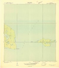
1940 Map of Manitou Island
USGS Topo · Published 1940About this map
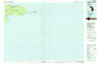
Manitou Island sits off the tip of the Grant peninsula, guarding the waters of Lake Superior in this preliminary 1940 survey. This remote maritime landscape is defined by its navigation aids, specifically the Manitou Island L H on the island's eastern edge and the Gull Rock L H on the tiny outcrop of Gull Rock to the west. The mainland portion of the map covers the dramatic eastern terminus of the Keweenaw Peninsula, including the prominent Keweenaw Point. Inland from the shoreline, Schlatter Lake and the wetlands of Union Creek dominate the interior of the Grant township section. The map's coastal detail includes named inlets such as Keystone Bay and High Rock Bay, showing the jagged interface between the rocky Michigan shoreline and the lake during the early 20th century.
Find a feature on this map
15 named features on this map. Tap any name to fly to it.
Don’t see what you’re looking for? This feature index may not catch every label — zoom into the map to look around manually.
Map Details
Editions of this 1940 Manitou Island Map
This is the sole edition of this map. No revisions or reprints were ever made.
Other maps of this area

1940 · Fort Wilkins
USGS Topo · 1:31,680

1948 · Fort Wilkins
USGS Topo · 1:24,000
1948 · Manitou Island
USGS Topo · 1:24,000
1949 · Manitou Island
USGS Topo · 1:24,000
1949 · Fort Wilkins
USGS Topo · 1:24,000

1958 · Hancock
USGS Topo · 1:250,000

1960 · Hancock
USGS Topo · 1:250,000

1961 · Hancock
USGS Topo · 1:250,000

1966 · Hancock
USGS Topo · 1:250,000
1985 · Copper Harbor
USGS Topo · 1:100,000