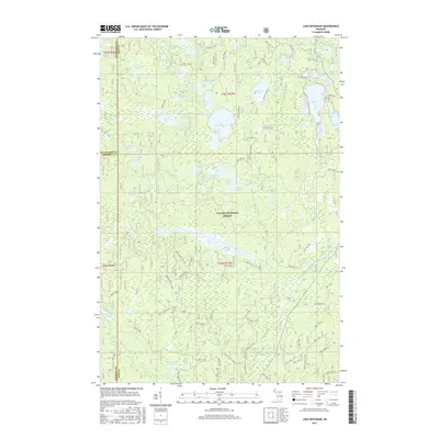
2017 Map of Lake Mitigwaki
USGS Topo · Published 2017About this map
Ottawa National Forest dominates this landscape in the western Upper Peninsula, where the borders of Iron, Gogebic, and Ontonagon counties converge. The terrain is defined by a dense concentration of glacial lakes and ponds, with Lake Mitigwaki and Paint Lake serving as central landmarks. Waterways like the Jumbo River wind through the timberland, supported by a network of forest service roads including Federal Forest 4100 Rd and Federal Forest 3340 Rd. The naming of the numerous small water bodies, such as Tinsel Lake, Mcpherson Lake, and Whisper Lake, reflects the remote and heavily wooded character of this region. This map provides a clear record of the intersection of these three counties and the extensive public land management in a sparsely populated section of Michigan.
Find a feature on this map
60 named features on this map. Tap any name to fly to it.
Don’t see what you’re looking for? This feature index may not catch every label — zoom into the map to look around manually.
Map Details
Editions of this 2017 Lake Mitigwaki Map
This is the sole edition of this map. No revisions or reprints were ever made.
Other maps of this area

1938 · Phelps
USGS Topo · 1:48,000

1950 · Phelps
USGS Topo · 1:48,000

1952 · Watersmeet
USGS Topo · 1:62,500

1954 · Kenton
USGS Topo · 1:62,500

1956 · Beechwood
USGS Topo · 1:62,500

1956 · Phelps
USGS Topo · 1:62,500

1958 · Iron River
USGS Topo · 1:250,000

1960 · Iron River
USGS Topo · 1:250,000

1961 · Iron River
USGS Topo · 1:250,000

1967 · Iron River
USGS Topo · 1:250,000
Featured Places
- Stambaugh Township, MI
- Interior Township, MI
- Watersmeet Township, MI
- Iron River Township, MI
- Gogebic County, MI