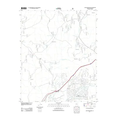
2011 Map of Lake Montezuma
USGS Topo · Published 2011About this map
Lake Montezuma and its neighboring settlements define this Arizona landscape as it appeared in the early 21st century. The map centers on the corridor where the Interstate highway meets local crossroads at the McGuireville interchange. Development is concentrated in the southern half of the sheet, with the residential street networks of Rimrock Ranch and Lake Montezuma following the course of Wet Beaver Creek and Russell Wash. Vital infrastructure is well-marked, including the Rimrock Post Office, the Lake Montezuma Post Office, and the Rimrock Airport.
Find a feature on this map
135 named features on this map. Tap any name to fly to it.
Don’t see what you’re looking for? This feature index may not catch every label — zoom into the map to look around manually.
Map Details
Editions of this 2011 Lake Montezuma Map
This is the sole edition of this map. No revisions or reprints were ever made.
Other maps of this area

1887 · Verde
USGS Topo · 1:250,000

1892 · Verde
USGS Topo · 1:250,000

1923 · Camp Verde
USGS Topo · 1:125,000

1932 · Camp Verde
USGS Topo · 1:125,000

1936 · Camp Verde
USGS Topo · 1:125,000

1954 · Holbrook
USGS Topo · 1:250,000

1957 · Holbrook
USGS Topo · 1:250,000

1958 · Holbrook
USGS Topo · 1:250,000

1960 · Holbrook
USGS Topo · 1:250,000
1965 · Munds Mountain
USGS Topo · 1:24,000