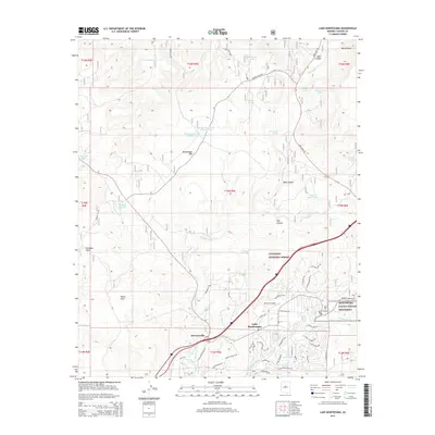
2014 Map of Lake Montezuma
USGS Topo · Published 2014About this map
Mcguireville and Lake Montezuma sit at the intersection of arid desert terrain and the lush riparian corridors of the Verde Valley. This 2014 survey illustrates the complex water management system of the high desert, where numerous man-made features like Beaverhead Tank Number One and Winter Cabin Tank support life away from the primary flows of Wet Beaver Cr and Dry Beaver Cr. The map details the transition from the residential street grids of Lake Montezuma to the protected wilderness of the Coconino National Forest. Significant cultural and natural landmarks are noted, including the archaeological importance of Montezuma Castle National Monument and the aviation hub at Rimrock Airport. The landscape is further defined by notable landforms such as the White Hills and the wide expanse of Beaverhead Flat, showing the modern infrastructure of State Hwy 179 as it cuts through the canyons.
Find a feature on this map
68 named features on this map. Tap any name to fly to it.
Don’t see what you’re looking for? This feature index may not catch every label — zoom into the map to look around manually.
Map Details
Editions of this 2014 Lake Montezuma Map
This is the sole edition of this map. No revisions or reprints were ever made.
Other maps of this area

1887 · Verde
USGS Topo · 1:250,000

1892 · Verde
USGS Topo · 1:250,000

1923 · Camp Verde
USGS Topo · 1:125,000

1932 · Camp Verde
USGS Topo · 1:125,000

1936 · Camp Verde
USGS Topo · 1:125,000

1954 · Holbrook
USGS Topo · 1:250,000

1957 · Holbrook
USGS Topo · 1:250,000

1958 · Holbrook
USGS Topo · 1:250,000

1960 · Holbrook
USGS Topo · 1:250,000
1965 · Munds Mountain
USGS Topo · 1:24,000