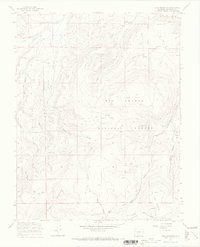
1967 Map of Lake Mountain
USGS Topo · Published 1969About this map
The La Garita Mountains define the high terrain of Saguache County in the late 1960s, a landscape characterized by its high-altitude meadows and vital water sources within the Rio Grande National Forest. The map documents a traditional western mountain economy through the presence of several Prospects and a network of livestock routes, including the Stock Driveway and Jeep Trail systems.
Find a feature on this map
24 named features on this map. Tap any name to fly to it.
Don’t see what you’re looking for? This feature index may not catch every label — zoom into the map to look around manually.
Map Details
Editions of this 1967 Lake Mountain Map
4 editions found
Other maps of this area

1914 · Creede
USGS Topo · 1:125,000

1915 · Del Norte
USGS Topo · 1:125,000

1916 · Creede
USGS Topo · 1:125,000

1917 · Del Norte
USGS Topo · 1:125,000

1945 · Durango
USGS Topo · 1:250,000

1953 · Durango
USGS Topo · 1:250,000

1954 · Durango
USGS Topo · 1:250,000

1956 · Montrose
USGS Topo · 1:250,000

1959 · Montrose
USGS Topo · 1:250,000

1960 · Montrose
USGS Topo · 1:250,000