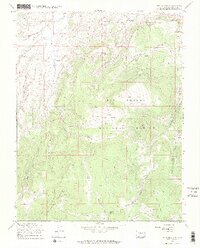
1967 Map of Lake Mountain
USGS Topo · Published 1969About this map
The La Garita Mountains define the high-elevation terrain of this region within the Rio Grande National Forest, where a complex network of seasonal creeks and gulches drains the southern Colorado landscape. Water sources like Saguache Creek, Luders Creek, and Squaw Creek cut through the topography, which is marked by several high-altitude parks, including South Park, Lower South Park, and Sunnyside Park. While the land is largely undeveloped, the presence of various Prospects suggests early mineral exploration in the hills near Mount Lion. Steep elevation changes are navigable primarily via the Jeep Trail and old forest tracks that connect the remote basins. Features like Carnero Pass and Lake Mountain serve as key landmarks for those tracing the historic land use and backcountry access points of the late 1960s.
Find a feature on this map
29 named features on this map. Tap any name to fly to it.
Don’t see what you’re looking for? This feature index may not catch every label — zoom into the map to look around manually.
Map Details
Editions of this 1967 Lake Mountain Map
4 editions found
Other maps of this area

1914 · Creede
USGS Topo · 1:125,000

1915 · Del Norte
USGS Topo · 1:125,000

1916 · Creede
USGS Topo · 1:125,000

1917 · Del Norte
USGS Topo · 1:125,000

1945 · Durango
USGS Topo · 1:250,000

1953 · Durango
USGS Topo · 1:250,000

1954 · Durango
USGS Topo · 1:250,000

1956 · Montrose
USGS Topo · 1:250,000

1959 · Montrose
USGS Topo · 1:250,000

1960 · Montrose
USGS Topo · 1:250,000