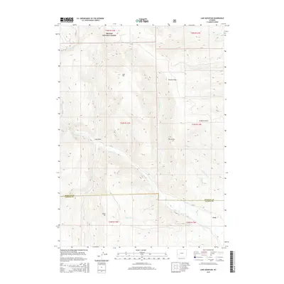
2015 Map of Lake Mountain
USGS Topo · Published 2015About this map
Bridger National Forest land dominates the upper elevations of this western Wyoming landscape, where the high ridges of Lake Mtn and Deadline Ridge overlook a complex network of canyons and drainages. The terrain is defined by deep incisions like Long Hollow and Graphite Hollow, which direct water into major arteries such as La Barge Cr. Near the southern border, the small settlement of Viola sits at the junction of Co Road 315 and CR-315, marking a point of human habitation where the foothills meet the flats of the river valley. The map reveals a land utilized for both its natural resources and livestock grazing, indicated by the presence of Beaver Dam Cr and numerous springs like Spring Cr. The boundary between Sublette and Lincoln Counties cuts through the lower third of the quadrangle, passing just north of Miller Mtn.
Find a feature on this map
30 named features on this map. Tap any name to fly to it.
Don’t see what you’re looking for? This feature index may not catch every label — zoom into the map to look around manually.
Map Details
Editions of this 2015 Lake Mountain Map
This is the sole edition of this map. No revisions or reprints were ever made.
Other maps of this area

1936 · Cokeville
USGS Topo · 1:96,000

1942 · Cokeville
USGS Topo · 1:125,000

1945 · Fort Hill
USGS Topo · 1:62,500

1947 · Fort Hill
USGS Topo · 1:62,500

1955 · Preston
USGS Topo · 1:250,000

1958 · Preston
USGS Topo · 1:250,000

1962 · Preston
USGS Topo · 1:250,000
1967 · Coal Creek
USGS Topo · 1:24,000

1967 · Mount Thompson
USGS Topo · 1:24,000
1967 · Fontenelle Basin
USGS Topo · 1:24,000