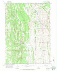
1967 Map of Coal Creek
USGS Topo · Published 1971About this map
The Bridger National Forest dominates this Wyoming landscape, revealing a complex drainage system within the Absaroka Ridge and Mahogany Ridge. This 1967 field check documents a wilderness area largely accessible only by a Pack Trail network, which winds through high-elevation terrain near the Lincoln and Sublette County boundary. The hydrological pattern is defined by major watercourses like La Barge Creek and Fontenelle Creek, fed by numerous named tributaries including Forked Creek, Lost Horse Creek, and Minnie Holden Creek. Distinctive geological formations like the Hogbacks and the broad Pomeroy Basin illustrate the transition from steep ridges to lower basin floors. For those studying the history of public land management or livestock grazing routes, the interplay of the forest boundary and the various creeks—including Coal Creek and Roaring Creek—provides a detailed view of the region's topographical character before modern road development.
Find a feature on this map
32 named features on this map. Tap any name to fly to it.
Don’t see what you’re looking for? This feature index may not catch every label — zoom into the map to look around manually.
Map Details
Editions of this 1967 Coal Creek Map
2 editions found
Other maps of this area

1936 · Cokeville
USGS Topo · 1:96,000

1942 · Cokeville
USGS Topo · 1:125,000

1945 · Fort Hill
USGS Topo · 1:62,500

1947 · Fort Hill
USGS Topo · 1:62,500

1955 · Preston
USGS Topo · 1:250,000

1958 · Preston
USGS Topo · 1:250,000

1962 · Preston
USGS Topo · 1:250,000
1967 · Pole Creek
USGS Topo · 1:24,000

1967 · Devils Hole Creek
USGS Topo · 1:24,000

1967 · Graham Peak
USGS Topo · 1:24,000