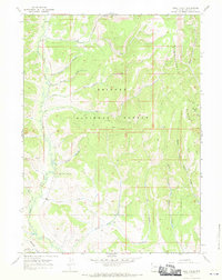
1967 Map of Pole Creek
USGS Topo · Published 1970About this map
The Bridger National Forest dominates this Wyoming landscape, revealing a high-altitude drainage network as it existed in the late 1960s. The terrain is characterized by the prominent Commissary Ridge and an intricate system of creeks that suggest a history of seasonal resource extraction. Names like Shingle Mill Creek and Sawmill Creek point toward early timber operations, while the numerous Jeep Trails and Pack Trails crisscrossing the slopes of Poison Hollow and Burke Creek reflect the area's use for backcountry access and livestock grazing. In the southern portion of the quadrangle, Pole Creek and Carl Creek flow through the valleys, providing a snapshot of the watershed before more modern developments. The map effectively documents the transition between the high ridges and the complex water systems of Hams Fork and Beaver Creek.
Find a feature on this map
27 named features on this map. Tap any name to fly to it.
Don’t see what you’re looking for? This feature index may not catch every label — zoom into the map to look around manually.
Map Details
Editions of this 1967 Pole Creek Map
This is the sole edition of this map. No revisions or reprints were ever made.
Other maps of this area

1936 · Cokeville
USGS Topo · 1:96,000

1942 · Cokeville
USGS Topo · 1:125,000

1955 · Preston
USGS Topo · 1:250,000

1958 · Preston
USGS Topo · 1:250,000

1962 · Preston
USGS Topo · 1:250,000

1967 · Devils Hole Creek
USGS Topo · 1:24,000

1967 · Big Park
USGS Topo · 1:24,000
1967 · Wilkinson Creek
USGS Topo · 1:24,000
1967 · Sublette Canyon
USGS Topo · 1:24,000
1967 · Coal Creek
USGS Topo · 1:24,000