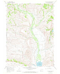
1967 Map of Wilkinson Creek
USGS Topo · Published 1970About this map
Hams Fork winds through this high-altitude landscape of southwestern Wyoming, providing the primary drainage for a network of mountain streams and irrigation works. In the late 1960s, the southern portion of the map is dominated by the reservoir of Lake Viva Naughton, while the surrounding terrain rises sharply toward the Hams Fork Plateau. The agricultural and ranching history of the area is evident in the extensive irrigation infrastructure, including the Johnson Spencer Ditch, Moore Ditch, and Smith Ditch, which redirect water across the uneven topography of Dempsey Basin. Remote access is marked by the Jack Trail and various jeep trails, reflecting a rugged environment of high ridges like Pink Hill and deep valleys carved by Wilkinson Creek and its tributaries. A Gaging Sta and Footbridge along the fork indicate the active management of these vital water resources.
Find a feature on this map
33 named features on this map. Tap any name to fly to it.
Don’t see what you’re looking for? This feature index may not catch every label — zoom into the map to look around manually.
Map Details
Editions of this 1967 Wilkinson Creek Map
This is the sole edition of this map. No revisions or reprints were ever made.
Other maps of this area

1936 · Cokeville
USGS Topo · 1:96,000

1942 · Cokeville
USGS Topo · 1:125,000

1954 · Sage
USGS Topo · 1:62,500

1954 · Ogden
USGS Topo · 1:250,000

1954 · Kemmerer
USGS Topo · 1:62,500

1955 · Preston
USGS Topo · 1:250,000

1958 · Ogden
USGS Topo · 1:250,000

1958 · Preston
USGS Topo · 1:250,000

1960 · Ogden
USGS Topo · 1:250,000

1962 · Preston
USGS Topo · 1:250,000