
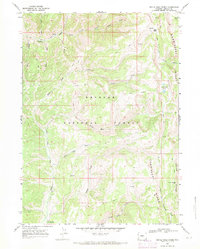
1967 Map of Devils Hole Creek
USGS Topo · Published 1970About this map
Bridger National Forest dominates this section of the Wyoming backcountry, defined by the high, parallel crests of Commissary Ridge and Indian Ridge. Mapped in the mid-1960s, the terrain is shaped by an intricate network of drainage basins, including Devils Hole Creek and Little Indian Creek. The landscape shows very little human footprint beyond essential access, centered on Hams Fork Campground and a system of pack trails and jeep trails used for forest management or recreation. Notable high-altitude features like Indian Mountain and Devils Hole Lakes underscore the elevation, while open areas like Red Park provide breaks in the wooded drainages. This survey documents the headwaters of several critical systems, such as South Fork Fontenelle Creek and the Fork Hams Fork, before more modern development or road expansion in the region.
Find a feature on this map
28 named features on this map. Tap any name to fly to it.
Don’t see what you’re looking for? This feature index may not catch every label — zoom into the map to look around manually.
Map Details
Editions of this 1967 Devils Hole Creek Map
2 editions found
Other maps of this area

1936 · Cokeville
USGS Topo · 1:96,000

1942 · Cokeville
USGS Topo · 1:125,000

1955 · Preston
USGS Topo · 1:250,000

1958 · Preston
USGS Topo · 1:250,000

1962 · Preston
USGS Topo · 1:250,000
1967 · Pole Creek
USGS Topo · 1:24,000

1967 · Graham Peak
USGS Topo · 1:24,000

1967 · Big Park
USGS Topo · 1:24,000

1967 · Porcupine Creek
USGS Topo · 1:24,000
1967 · Coal Creek
USGS Topo · 1:24,000