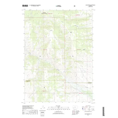
2017 Map of Lake Mountain
USGS Topo · Published 2017About this map
Bridger National Forest land dominates this high-elevation landscape in western Wyoming, where the terrain is defined by prominent landforms like Lake Mtn and the long stretch of Deadline Ridge. The map reveals a drainage network where La Barge Creek and its many tributaries, such as Sheep Creek and Cabin Creek, have carved deep notches into the plateau, creating named landforms like Long Hollow and Graphite Hollow. A network of back-country routes, including La Barge Creek Road and Beaver Dam Creek Road, provides the primary access through this remote forest and BLM-managed territory. Further south, the boundary between Sublette and Lincoln counties crosses the map near Miller Mtn, marking a transition in local jurisdiction. The detailed hydrography of creeks like Pickett Creek and Spring Creek illustrates the complex watershed management within this rugged portion of the state.
Find a feature on this map
30 named features on this map. Tap any name to fly to it.
Don’t see what you’re looking for? This feature index may not catch every label — zoom into the map to look around manually.
Map Details
Editions of this 2017 Lake Mountain Map
This is the sole edition of this map. No revisions or reprints were ever made.
Other maps of this area

1936 · Cokeville
USGS Topo · 1:96,000

1942 · Cokeville
USGS Topo · 1:125,000

1945 · Fort Hill
USGS Topo · 1:62,500

1947 · Fort Hill
USGS Topo · 1:62,500

1955 · Preston
USGS Topo · 1:250,000

1958 · Preston
USGS Topo · 1:250,000

1962 · Preston
USGS Topo · 1:250,000
1967 · Coal Creek
USGS Topo · 1:24,000

1967 · Mount Thompson
USGS Topo · 1:24,000
1967 · Fontenelle Basin
USGS Topo · 1:24,000