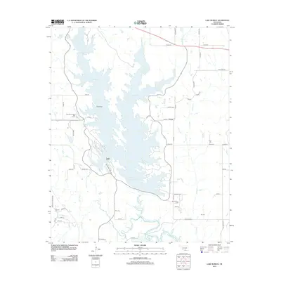
2012 Map of Lake Murray
USGS Topo · Published 2012About this map
Lake Murray dominates this landscape, its irregular shoreline reaching into Oklahoma's southern interior via the West Anadarche Arm, East Anadarche Arm, and Fourche Maline Arm. The map details a sophisticated network of recreation and local transit, anchored by the iconic Tucker Tower and Lake Murray State Park Airport. Small family and community landmarks like Wilson Cem and Ran Cem are situated on the surrounding uplands near the small settlement of Hoxbar. The terrain is deeply carved by drainage systems including Pumpkin Cr and Hickory Cr, which feed the reservoir's complex structure. This survey documents the intersection of rural Oklahoma life and mid-century state park development, showing how secondary roads like Legate Rd and Pear Orchard Rd connect long-standing homesteads to the modernized waterfront.
Find a feature on this map
58 named features on this map. Tap any name to fly to it.
Don’t see what you’re looking for? This feature index may not catch every label — zoom into the map to look around manually.
Map Details
Editions of this 2012 Lake Murray Map
This is the sole edition of this map. No revisions or reprints were ever made.
Other maps of this area

1901 · Tishomingo
USGS Topo · 1:125,000

1901 · Ardmore
USGS Topo · 1:125,000

1901 · Denison
USGS Topo · 1:125,000

1902 · Gainesville
USGS Topo · 1:125,000

1918 · Ardmore
USGS Topo · 1:125,000

1943 · Gainesville
USGS Topo · 1:125,000

1954 · Sherman
USGS Topo · 1:250,000

1957 · Ardmore
USGS Topo · 1:250,000

1958 · Gordonville
USGS Topo · 1:62,500

1958 · Sherman
USGS Topo · 1:250,000