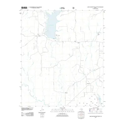
2010 Map of Lake Nacogdoches South
USGS Topo · Published 2010About this map
Lake Nacogdoches dominates the northern landscape, its southern reaches held by the Loco Dam near the community of Eden. This rural Texas corridor is defined by the winding course of Bayou Loco as it travels south toward the Angelina River, which snakes through the southwest corner of the map along its Old River Channel. The settlement patterns here reflect a long-standing agricultural and community network, evidenced by the presence of local centers like Alazan and Harmony. Genealogy researchers will find several localized landmarks preserved in the record, including the Eden School and Alazan School, alongside the Eden Cemetery and Watson Cemetery. The map also captures several smaller private water bodies, such as Tank Johnson Lake and Alazan Lake, each managed by its respective dam, illustrating the local importance of water management and land ownership in Nacogdoches County.
Find a feature on this map
51 named features on this map. Tap any name to fly to it.
Don’t see what you’re looking for? This feature index may not catch every label — zoom into the map to look around manually.
Map Details
Editions of this 2010 Lake Nacogdoches South Map
This is the sole edition of this map. No revisions or reprints were ever made.
Other maps of this area

1949 · Lufkin
USGS Topo · 1:62,500

1949 · Clawson
USGS Topo · 1:24,000

1950 · Clawson
USGS Topo · 1:24,000

1950 · Redland
USGS Topo · 1:24,000

1951 · Wells
USGS Topo · 1:24,000

1952 · Douglass
USGS Topo · 1:62,500

1952 · Nacogdoches
USGS Topo · 1:62,500

1953 · Palestine
USGS Topo · 1:250,000

1957 · Palestine
USGS Topo · 1:250,000
1983 · Durst Lakes
USGS Topo · 1:24,000