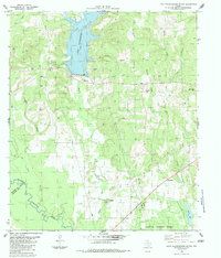
1983 Map of Lake Nacogdoches South
USGS Topo · Published 1983About this map
Lake Nacogdoches dominates the northern landscape of this 1983 survey, where the recently impounded waters contrast with the established rural character of the Angelina National Forest to the south. Small settlements and crossroads like Eden, Alazan, and Bonaldo anchor a region defined by its numerous waterways, including Loco Bayou and Alazan Bayou, which snake toward the Angelina River at the southern boundary. Genealogists and local historians can trace the community life of the era through the presence of Pleasant View Ch and several burial grounds such as Watson Cem and Gravel Ridge Cem. The transition from the lake's controlled inundation areas to the southern bottomlands illustrates the shifting geography of Nacogdoches County as modern infrastructure, like the nearby Filtration Plant and various pipelines, integrated into the traditional timber and river landscape.
Find a feature on this map
29 named features on this map. Tap any name to fly to it.
Don’t see what you’re looking for? This feature index may not catch every label — zoom into the map to look around manually.
Map Details
Editions of this 1983 Lake Nacogdoches South Map
This is the sole edition of this map. No revisions or reprints were ever made.
Other maps of this area

1949 · Lufkin
USGS Topo · 1:62,500

1949 · Clawson
USGS Topo · 1:24,000

1950 · Clawson
USGS Topo · 1:24,000

1950 · Redland
USGS Topo · 1:24,000

1951 · Wells
USGS Topo · 1:24,000

1952 · Douglass
USGS Topo · 1:62,500

1952 · Nacogdoches
USGS Topo · 1:62,500

1953 · Palestine
USGS Topo · 1:250,000

1957 · Palestine
USGS Topo · 1:250,000
1983 · Durst Lakes
USGS Topo · 1:24,000