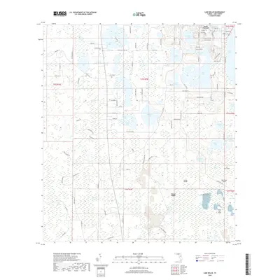
2018 Map of Lake Nellie
USGS Topo · Published 2018About this map
South Clermont sits at the northern edge of a landscape defined by an intricate network of interconnected wetlands and lakes in this 2018 study. The terrain transitions from the residential developments near Lake Nellie and Little Lake Nellie into the vast hydrological system of the Green Swamp. Numerous family-named landmarks and water bodies, such as Saw Mill Lake and Kirkland Lake, suggest a history of local land use tied to the water table. The southern half of the map reveals a complex environment of islands and marshes, including the named Wilson Islands, Joe Lee Island, and Black Jack Island. This area, part of the larger Citrus Ridge region, illustrates the persistence of Florida's freshwater ecosystems amidst modern road corridors like Co Rd 561. Isolated swamps like Alligator Lake Swamp and Loggy Pond Swamp highlight the native character of the Lake County interior before more intensive modern drainage.
Find a feature on this map
109 named features on this map. Tap any name to fly to it.
Don’t see what you’re looking for? This feature index may not catch every label — zoom into the map to look around manually.
Map Details
Editions of this 2018 Lake Nellie Map
This is the sole edition of this map. No revisions or reprints were ever made.
Other maps of this area

1955 · Orlando
USGS Topo · 1:250,000

1957 · Orlando
USGS Topo · 1:250,000

1958 · Orlando
USGS Topo · 1:250,000

1959 · Lake Nellie
USGS Topo · 1:24,000

1959 · Lake Louisa
USGS Topo · 1:24,000

1959 · Lake Louisa SW
USGS Topo · 1:24,000

1959 · Poyner
USGS Topo · 1:24,000
1960 · Bay Lake
USGS Topo · 1:24,000
1960 · Rock Ridge
USGS Topo · 1:24,000

1962 · Orlando
USGS Topo · 1:250,000