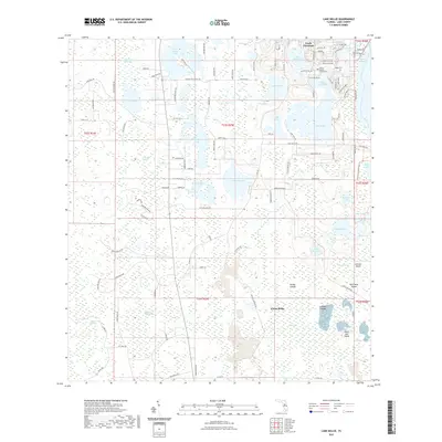
2021 Map of Lake Nellie
USGS Topo · Published 2021About this map
South Clermont and the developing area of Citrus Ridge sit at the center of this complex Florida hydrologic network. The landscape is defined by its numerous named water bodies, ranging from the large Lake Nellie and Lake Louisa to smaller features like Pretty Lake and Lake Glona. This 2021 topographic survey provides a detailed view of how residential roads like Florida Boys Ranch Rd and Lakeshore Ranch Rd have integrated into a terrain historically dominated by swamps.
Find a feature on this map
116 named features on this map. Tap any name to fly to it.
Don’t see what you’re looking for? This feature index may not catch every label — zoom into the map to look around manually.
Map Details
Editions of this 2021 Lake Nellie Map
This is the sole edition of this map. No revisions or reprints were ever made.
Other maps of this area

1955 · Orlando
USGS Topo · 1:250,000

1957 · Orlando
USGS Topo · 1:250,000

1958 · Orlando
USGS Topo · 1:250,000

1959 · Lake Nellie
USGS Topo · 1:24,000

1959 · Lake Louisa
USGS Topo · 1:24,000

1959 · Lake Louisa SW
USGS Topo · 1:24,000

1959 · Poyner
USGS Topo · 1:24,000
1960 · Bay Lake
USGS Topo · 1:24,000
1960 · Rock Ridge
USGS Topo · 1:24,000

1962 · Orlando
USGS Topo · 1:250,000