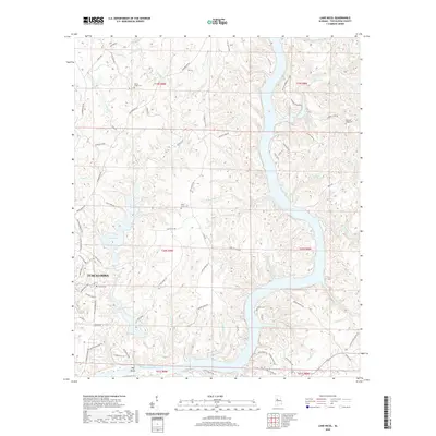
2020 Map of Lake Nicol
USGS Topo · Published 2020About this map
Lake Nicol and Lake Harris dominate this section of the Alabama landscape north of Tuscaloosa, illustrating a topography defined by significant water management and the rugged winding course of the Black Warrior River system. The river itself is represented here by the expansive Holt Lake and William Bacon Oliver Lake, which stretch through the terrain where Hog Shoals once marked the natural riverbed. Historically significant sites are scattered throughout the wooded ridges, including numerous family and community burial grounds such as Yellow Creek Cem, Piney Grove Cem, and Pleasant Ridge Cem. The intricate network of small waterways like Hurricane Cr, Cypress Cr, and Sexton Spring Br feeds into the larger reservoirs, shaping the development of local roads like Watermelon Rd and Old Lock 15 Rd that navigate the varied elevation.
Find a feature on this map
83 named features on this map. Tap any name to fly to it.
Don’t see what you’re looking for? This feature index may not catch every label — zoom into the map to look around manually.
Map Details
Editions of this 2020 Lake Nicol Map
This is the sole edition of this map. No revisions or reprints were ever made.
Other maps of this area

1899 · Brookwood
USGS Topo · 1:125,000

1924 · Tuscaloosa
USGS Topo · 1:62,500

1926 · Samantha
USGS Topo · 1:48,000

1926 · Tuscaloosa
USGS Topo · 1:62,500

1928 · Samantha
USGS Topo · 1:62,500

1929 · Searles
USGS Topo · 1:48,000

1931 · Cottondale
USGS Topo · 1:48,000

1934 · Searles
USGS Topo · 1:62,500

1934 · Cottondale
USGS Topo · 1:62,500

1953 · Birmingham
USGS Topo · 1:250,000
Featured Places
- Tuscaloosa, AL
- Grand Arbor, Tuscaloosa
- Shamley Green, Tuscaloosa
- Harbor Ridge, Tuscaloosa
- Signal Hill, Tuscaloosa