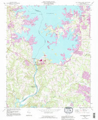
1993 Map of Lake Norman South
USGS Topo · Published 1996About this map
Lake Norman dominates the landscape of this region north of Charlotte, where the damming of the Catawba River reshaped the borders of Mecklenburg, Lincoln, and Gaston counties. The map captures a transition toward recreation and residential development along the shorelines of Graham Creek, Lucky Creek, and Hager Creek. Despite the growth in communities like Cornelius and Westport, older rural landmarks remain visible, including Ebenezer Cem, Unity Ch, and the Triangle Sch.
Find a feature on this map
54 named features on this map. Tap any name to fly to it.
Don’t see what you’re looking for? This feature index may not catch every label — zoom into the map to look around manually.
Map Details
Editions of this 1993 Lake Norman South Map
This is the sole edition of this map. No revisions or reprints were ever made.
Other maps of this area

1893 · Statesville
USGS Topo · 1:125,000

1895 · Hickory
USGS Topo · 1:125,000

1914 · Gastonia
USGS Topo · 1:48,000

1916 · Gastonia
USGS Topo · 1:62,500

1941 · Charlotte
USGS Topo · 1:125,000

1942 · Charlotte
USGS Topo · 1:125,000

1948 · Paw Creek
USGS Topo · 1:24,000

1948 · Derita
USGS Topo · 1:24,000

1949 · Hicks Crossroads
USGS Topo · 1:24,000

1953 · Charlotte
USGS Topo · 1:250,000