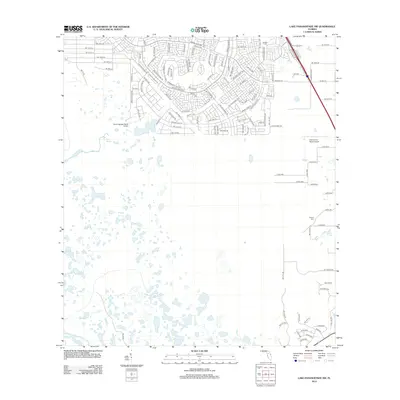
2012 Map of Lake Panasoffkee NW
USGS Topo · Published 2012About this map
Gum Springs and the winding Gum Slough define the hydrologic character of this Central Florida landscape, where wetlands meet emerging residential development. The northern portion of the map is dominated by the dense street network of Marion Oaks, including thoroughfares such as Marion Oaks Blvd and Marion Oaks Golf Way. This planned community development contrasts sharply with the expansive, low-lying marshes to the south. Transportation and utility are marked by the presence of private aviation facilities like Seven Springs Ranch Airport and S & S Avion Ranch Airport. For genealogists and local historians, the Nichols Cem serves as a small but significant site of local heritage, situated away from the primary residential corridors. The map captures a period of transition as suburbia extends into the Florida interior.
Find a feature on this map
115 named features on this map. Tap any name to fly to it.
Don’t see what you’re looking for? This feature index may not catch every label — zoom into the map to look around manually.
Map Details
Editions of this 2012 Lake Panasoffkee NW Map
This is the sole edition of this map. No revisions or reprints were ever made.
Other maps of this area

1892 · Dunnellon
USGS Topo · 1:62,500

1893 · Panasoffkee
USGS Topo · 1:62,500

1894 · Dunnellon
USGS Topo · 1:62,500

1895 · Tsala Apopka
USGS Topo · 1:62,500

1895 · Panasoffkee
USGS Topo · 1:62,500

1895 · Ocala
USGS Topo · 1:62,500

1954 · Tsala Apopka NE
USGS Topo · 1:24,000

1954 · Inverness
USGS Topo · 1:24,000

1954 · Dunnellon SE
USGS Topo · 1:24,000

1954 · Inverness
USGS Topo · 1:62,500