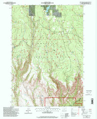
1995 Map of Lake Penland
USGS Topo · Published 1998About this map
Umatilla National Forest lands dominate this high-country survey of the Blue Mountains region, highlighting the infrastructure of federal land management in the mid-1990s. The map centers on the reservoir at Lake Penland, showing its spillway elevation alongside various forest management sites like the Ditch Creek Forest Service Station and the Mallory Seed Orchard. The landscape is a network of steep drainages including Deep Canyon and Long Canyon, with numerous water sources such as Wickiup Spring and Doghouse Spring supporting the high-elevation terrain.
Find a feature on this map
37 named features on this map. Tap any name to fly to it.
Don’t see what you’re looking for? This feature index may not catch every label — zoom into the map to look around manually.
Map Details
Editions of this 1995 Lake Penland Map
This is the sole edition of this map. No revisions or reprints were ever made.
Other maps of this area

1950 · Ritter
USGS Topo · 1:62,500

1951 · Monument
USGS Topo · 1:62,500

1952 · Ritter
USGS Topo · 1:62,500

1953 · Pendleton
USGS Topo · 1:250,000

1955 · Canyon City
USGS Topo · 1:250,000

1956 · Pendleton
USGS Topo · 1:250,000

1959 · Canyon City
USGS Topo · 1:250,000

1969 · Summerfield Ridge
USGS Topo · 1:24,000

1969 · Lake Penland
USGS Topo · 1:24,000

1969 · Thompson Flat
USGS Topo · 1:24,000