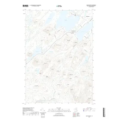
2019 Map of Lake Pleasant
USGS Topo · Published 2019About this map
The Hamilton County Courthouse stands as a central landmark in the village of Lake Pleasant, situated on the narrow strip of land between Sacandaga Lake and Lake Pleasant. This area of the Adirondacks shows a landscape defined by its high density of glacial lakes and mountain peaks. To the northeast, the settlement of Speculator marks a primary crossroads, while the shoreline of Sacandaga Lake is characterized by recreation sites like Moffit Beach. The interior terrain is a complex network of summits including Fish Mtn and Mt Francisco, interspersed with secluded water bodies such as Fawn Lake and Oxbow Lake. Local history is preserved in small sites like Fish Mountain Cem and Love's Cem, while the West Branch Sacandaga River drains the southern highlands near Big Eddy.
Find a feature on this map
75 named features on this map. Tap any name to fly to it.
Don’t see what you’re looking for? This feature index may not catch every label — zoom into the map to look around manually.
Map Details
Editions of this 2019 Lake Pleasant Map
This is the sole edition of this map. No revisions or reprints were ever made.
Other maps of this area

1899 · Indian Lake
USGS Topo · 1:62,500

1900 · Canada Lake
USGS Topo · 1:62,500

1902 · Indian Lake
USGS Topo · 1:62,500

1903 · West Canada Lakes
USGS Topo · 1:62,500

1904 · Piseco Lake
USGS Topo · 1:62,500

1906 · Piseco Lake
USGS Topo · 1:62,500

1907 · Lake Pleasant
USGS Topo · 1:62,500

1908 · Piseco Lake
USGS Topo · 1:62,500

1950 · Utica
USGS Topo · 1:250,000

1954 · Lake Pleasant
USGS Topo · 1:62,500