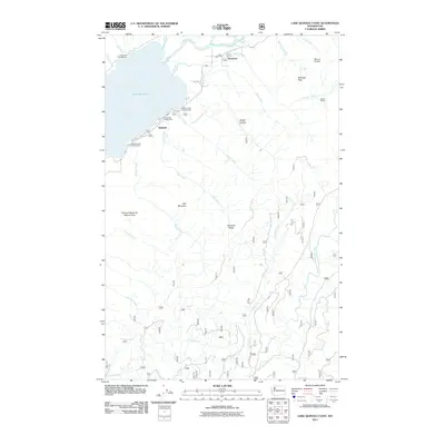
2011 Map of Lake Quinault East
USGS Topo · Published 2011About this map
Quinault and the smaller settlement of Norwood sit at the northeastern head of Lake Quinault, where the Quinault River feeds into the basin. This Olympic Peninsula landscape is defined by its deep connectivity to the water, shown through an extensive network of creeks including Merriman Creek, Ziegler Creek, and Haas Creek that drain from the high elevations of Mount O'Neil and Wooded Peak. The presence of several established recreational sites like the July Creek Campground and Willaby Creek Forest Camp indicates the area's long-standing role as a gateway for forestry and outdoor research, further emphasized by the dedicated Quinault Research Natural Area. To the south, the terrain shifts into the drainage basin for the West Fork Humptulips River, while landmarks like the Mulkey Shelter provide specific points of interest for those tracing the historical routes through the Quinault Ridge.
Find a feature on this map
33 named features on this map. Tap any name to fly to it.
Don’t see what you’re looking for? This feature index may not catch every label — zoom into the map to look around manually.
Map Details
Editions of this 2011 Lake Quinault East Map
This is the sole edition of this map. No revisions or reprints were ever made.
Other maps of this area

1921 · Quinault Lake
USGS Topo · 1:62,500

1921 · Satsop
USGS Topo · 1:62,500

1947 · Mt Christie
USGS Topo · 1:62,500

1950 · Mt Christie
USGS Topo · 1:62,500

1955 · Grisdale
USGS Topo · 1:62,500

1955 · Quinault Lake
USGS Topo · 1:62,500

1956 · Kloochman Rock
USGS Topo · 1:62,500

1958 · Seattle
USGS Topo · 1:250,000

1962 · Seattle
USGS Topo · 1:250,000
1988 · Shelton
USGS Topo · 1:100,000