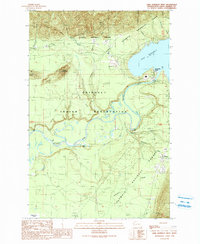
1990 Map of Lake Quinault West
USGS Topo · Published 1990About this map
The Quinault Indian Reservation covers the heart of this landscape, where the Quinault River flows from the glacial waters of Lake Quinault toward the Pacific. Along the northern and eastern fringes, the map documents the transition into protected federal lands within Olympic National Forest and Olympic National Park. The local economy of the late twentieth century is evidenced by various Gravel Pits and a Substation near the settlement of Amanda Park.
Find a feature on this map
29 named features on this map. Tap any name to fly to it.
Don’t see what you’re looking for? This feature index may not catch every label — zoom into the map to look around manually.
Map Details
Editions of this 1990 Lake Quinault West Map
This is the sole edition of this map. No revisions or reprints were ever made.
Other maps of this area

1921 · Quinault Lake
USGS Topo · 1:62,500

1943 · Copalis Beach
USGS Topo · 1:250,000

1951 · Copalis Beach
USGS Topo · 1:250,000

1955 · Macafee Hill
USGS Topo · 1:62,500

1955 · Quinault Lake
USGS Topo · 1:62,500

1956 · Kloochman Rock
USGS Topo · 1:62,500

1956 · Salmon River
USGS Topo · 1:62,500

1957 · Copalis Beach
USGS Topo · 1:250,000

1958 · Seattle
USGS Topo · 1:250,000

1962 · Seattle
USGS Topo · 1:250,000