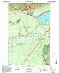
1995 Map of Lake Quinault West
USGS Topo · Published 1997About this map
The Quinault River dominates this landscape, winding through a complex network of jurisdictional lines that define the region's history. The map illustrates the proximity of the Quinault Indian Reservation to the Olympic National Forest, separated by significant markers like the Old Indian Treaty Boundary. Settlement is concentrated at the edge of Lake Quinault in Amanda Park and further south at Neilton, providing a look at local infrastructure including the Quinault School and a Gaging Station.
Find a feature on this map
31 named features on this map. Tap any name to fly to it.
Don’t see what you’re looking for? This feature index may not catch every label — zoom into the map to look around manually.
Map Details
Editions of this 1995 Lake Quinault West Map
This is the sole edition of this map. No revisions or reprints were ever made.
Other maps of this area

1921 · Quinault Lake
USGS Topo · 1:62,500

1943 · Copalis Beach
USGS Topo · 1:250,000

1951 · Copalis Beach
USGS Topo · 1:250,000

1955 · Macafee Hill
USGS Topo · 1:62,500

1955 · Quinault Lake
USGS Topo · 1:62,500

1956 · Kloochman Rock
USGS Topo · 1:62,500

1956 · Salmon River
USGS Topo · 1:62,500

1957 · Copalis Beach
USGS Topo · 1:250,000

1958 · Seattle
USGS Topo · 1:250,000

1962 · Seattle
USGS Topo · 1:250,000