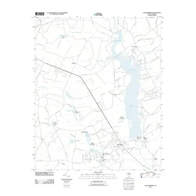
2011 Map of Lake Robinson
USGS Topo · Published 2011About this map
Lake Robinson serves as the central focal point of this landscape, fed by the waters of Black Creek and Lower Alligator Creek. The surrounding area is marked by a complex network of smaller water bodies and millponds, suggesting a history deeply tied to local drainage and water management. Small settlements such as Pine Ridge, Clyde, and New Market dot the crossroads, while family and community landmarks provide a window into the region's genealogical history. Several burial grounds, including Union Cemetery, McLean Cemetery, and the Antioch Cemetery, are distributed across the terrain, often near old road alignments like W Old Camden Rd. The presence of features such as Beaverdam Millpond and King Millpond indicates the long-standing importance of these creek systems to the local economy and community development in this part of South Carolina.
Find a feature on this map
107 named features on this map. Tap any name to fly to it.
Don’t see what you’re looking for? This feature index may not catch every label — zoom into the map to look around manually.
Map Details
Editions of this 2011 Lake Robinson Map
This is the sole edition of this map. No revisions or reprints were ever made.
Other maps of this area

1941 · Spartanburg
USGS Topo · 1:250,000

1953 · Spartanburg
USGS Topo · 1:250,000

1960 · Spartanburg
USGS Topo · 1:250,000

1963 · Spartanburg
USGS Topo · 1:250,000

1964 · Spartanburg
USGS Topo · 1:250,000

1967 · Angelus
USGS Topo · 1:24,000

1968 · Patrick
USGS Topo · 1:24,000

1968 · Middendorf
USGS Topo · 1:24,000
1968 · Hartsville North
USGS Topo · 1:24,000
1968 · Lake Robinson
USGS Topo · 1:24,000