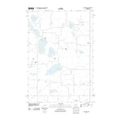
2010 Map of Lake Simon
USGS Topo · Published 2010About this map
The East Branch Chippewa River meanders through this agricultural landscape in Kandiyohi County, feeding into a series of glacial lakes including Scandinavian Lake, Gilchrist Lake, and the central Lake Simon. The survey reveals a region defined by small family plots and religious heritage, as evidenced by several secluded burial grounds like the Sather Family Cemetery and the Hitman Family Cemetery. Cultural markers such as the Scandia Lutheran Cemetery and the Seventh Day Adventist Cemetery highlight the local settlement patterns of the area. Beyond the water bodies, the map tracks several tributaries like Mud Creek and Spring Creek, alongside the Bohmer Wildlife Pond Dam, which indicates modern conservation and water management efforts within the traditional township road grid.
Find a feature on this map
50 named features on this map. Tap any name to fly to it.
Don’t see what you’re looking for? This feature index may not catch every label — zoom into the map to look around manually.
Map Details
Editions of this 2010 Lake Simon Map
This is the sole edition of this map. No revisions or reprints were ever made.
Other maps of this area

1953 · Saint Cloud
USGS Topo · 1:250,000

1957 · Saint Cloud
USGS Topo · 1:250,000

1958 · Saint Cloud
USGS Topo · 1:250,000

1965 · Sedan
USGS Topo · 1:24,000

1967 · Sunburg
USGS Topo · 1:24,000

1967 · Lake Johanna
USGS Topo · 1:24,000

1968 · De Graff
USGS Topo · 1:24,000

1968 · Terrace
USGS Topo · 1:24,000

1968 · Lake Simon
USGS Topo · 1:24,000
1968 · Lake Minnewaska
USGS Topo · 1:24,000