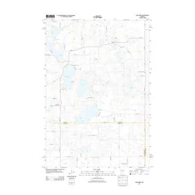
2013 Map of Lake Simon
USGS Topo · Published 2013About this map
Lake Simon anchors this West Central Minnesota landscape, where the borders of Pope, Swift, and Kandiyohi counties converge among a glacial lake chain. This 2013 survey illustrates a rural environment defined by water and small-scale agriculture, with the E Br Chippewa River feeding into Gilchrist Lake before winding south. The map is particularly notable for its dense cluster of family and community burial grounds, such as the Scandia Lutheran Cem and the Hitman Family Cem, which suggest a long-established settlement pattern of dispersed farmsteads rather than centralized towns.
Find a feature on this map
53 named features on this map. Tap any name to fly to it.
Don’t see what you’re looking for? This feature index may not catch every label — zoom into the map to look around manually.
Map Details
Editions of this 2013 Lake Simon Map
This is the sole edition of this map. No revisions or reprints were ever made.
Other maps of this area

1953 · Saint Cloud
USGS Topo · 1:250,000

1957 · Saint Cloud
USGS Topo · 1:250,000

1958 · Saint Cloud
USGS Topo · 1:250,000

1965 · Sedan
USGS Topo · 1:24,000

1967 · Sunburg
USGS Topo · 1:24,000

1967 · Lake Johanna
USGS Topo · 1:24,000

1968 · De Graff
USGS Topo · 1:24,000

1968 · Terrace
USGS Topo · 1:24,000

1968 · Lake Simon
USGS Topo · 1:24,000
1968 · Lake Minnewaska
USGS Topo · 1:24,000