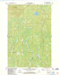
1984 Map of Lake Six
USGS Topo · Published 1984About this map
Waterways and forestry routes dominate this corner of the Northwoods, where the Chippewa River and its tributaries carve through the townships of Knight, Mercer, and Agenda. The landscape is defined by its complex drainage patterns, with Swamp Creek and Hurd Creek winding through lowlands punctuated by small basins like Lake Six and Duck Lake. Evidence of early logging and transport infrastructure is visible in the presence of the Roddis Grade and Chippewa Lane, tracing the historical movement of timber through the area. In the northern reaches, the Pleasant Lake Lookout Tower stands as a sentinel over the dense terrain, marking a period of active fire surveillance in the Wisconsin wilderness. This 1984 update, based on photography from the mid-1960s and early 1980s, captures the boundary where Iron and Ashland Counties meet, preserving the alignment of local roads and remote Gravel Pits used for rural maintenance.
Find a feature on this map
15 named features on this map. Tap any name to fly to it.
Don’t see what you’re looking for? This feature index may not catch every label — zoom into the map to look around manually.
Map Details
Editions of this 1984 Lake Six Map
This is the sole edition of this map. No revisions or reprints were ever made.
Other maps of this area

1940 · Mercer
USGS Topo · 1:48,000

1940 · Butternut
USGS Topo · 1:48,000

1940 · Upson
USGS Topo · 1:48,000

1943 · Upson
USGS Topo · 1:48,000

1943 · Ironwood
USGS Topo · 1:48,000

1945 · Mercer
USGS Topo · 1:48,000

1947 · Butternut
USGS Topo · 1:48,000

1947 · Mercer
USGS Topo · 1:48,000

1950 · Butternut
USGS Topo · 1:48,000

1953 · Ashland
USGS Topo · 1:250,000