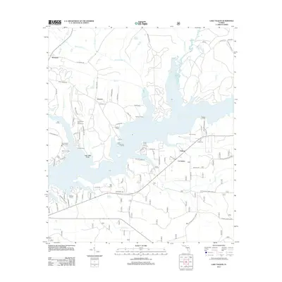
2012 Map of Lake Talquin
USGS Topo · Published 2012About this map
Lake Talquin dominates this landscape, its sprawling fingers and numerous landings defining the local geography and settlement patterns. Numerous waterfront access points such as Rawlings Landing, Browns Landing, and Davis Boat Landing reflect the importance of the reservoir for recreation and community identity. The map illustrates a mix of wooded preserves and small rural settlements, most notably Ebenezer and Holland, alongside the Wallwood Boy Scout Camp Reserve. On the eastern shore, Fort Braden serves as a local hub near the Fort Braden Cem. The road network is a blend of modern corridors and historic routes like the Old Federal Rd in the northwest. Tributaries such as the Little River and Rocky Comfort Cr feed the lake, while smaller branches like Mule Cr and Polk Cr carve through the surrounding timberlands and hillsides.
Find a feature on this map
93 named features on this map. Tap any name to fly to it.
Don’t see what you’re looking for? This feature index may not catch every label — zoom into the map to look around manually.
Map Details
Editions of this 2012 Lake Talquin Map
This is the sole edition of this map. No revisions or reprints were ever made.
Other maps of this area

1940 · Tallahassee
USGS Topo · 1:62,500

1942 · Tallahassee
USGS Topo · 1:62,500

1943 · Tallahassee
USGS Topo · 1:62,500

1943 · Lake Talquin
USGS Topo · 1:62,500

1954 · Tallahassee
USGS Topo · 1:250,000

1959 · Tallahassee
USGS Topo · 1:250,000

1959 · Gretna
USGS Topo · 1:24,000

1959 · Quincy
USGS Topo · 1:24,000

1960 · Tallahassee
USGS Topo · 1:250,000
1963 · Havana South
USGS Topo · 1:24,000