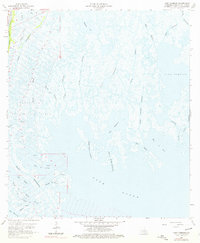
1964 Map of Lake Tambour
USGS Topo · Published 1976About this map
Lapeyrouse Oil and Gas Field anchors the western portion of this Terrebonne Parish landscape, where industrial extraction meets the intricate salt marshes of the Louisiana coast. The territory is defined by an expansive network of waterways, from the major artery of Bayou Terrebonne to smaller channels like Bayou Dufrene and Bayou Theriot. The map details a shifting amphibious world where land and water are inextricably linked, evidenced by the numerous gas wells and a Drill Hole scattered across the wetlands near Bayou la Fleur. Toward the east, the open waters of Lake Tambour and Lake Barre dominate, separated from the interior by tidal passes such as Oyster Bayou. The presence of a Portage and the convergence of various bayous, including Grand Bayou Bourbeux and Petit Bayou Bourbeux, reflect the historical reliance on waterborne transit in a region where conventional roads are nearly absent.
Find a feature on this map
34 named features on this map. Tap any name to fly to it.
Don’t see what you’re looking for? This feature index may not catch every label — zoom into the map to look around manually.
Map Details
Editions of this 1964 Lake Tambour Map
4 editions found
Other maps of this area

1894 · Timbalier
USGS Topo · 1:62,500

1894 · Lake Felicity
USGS Topo · 1:62,500

1894 · Dulac
USGS Topo · 1:62,500

1935 · Cocodrie
USGS Topo · 1:31,680

1935 · Bourbeux
USGS Topo · 1:31,680

1935 · Viguerie Canal
USGS Topo · 1:31,680

1935 · Montegut
USGS Topo · 1:31,680

1935 · Lake Quitman
USGS Topo · 1:31,680

1935 · Lake Gero
USGS Topo · 1:31,680

1939 · Lake Felicity
USGS Topo · 1:62,500