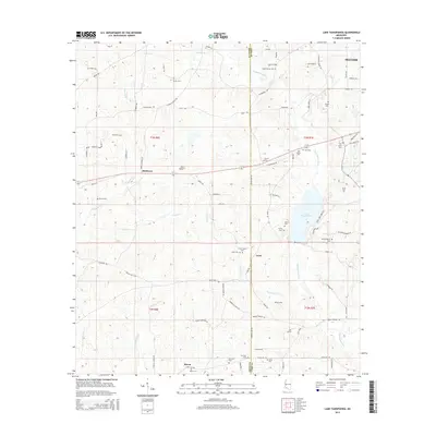
2015 Map of Lake Tangipahoa
USGS Topo · Published 2015About this map
The Tangipahoa River and its varied tributaries, including Wilson Cr, Hominy Cr, and Hurricane Cr, define the drainage of this Mississippi borderland. The landscape is dotted with small family and community burial sites such as Butler Cem, Josiah Powell Cem, and Rose Bower Cem, which offer significant genealogical clues for researchers of Pike and Amite counties. Central to the area is Lake Tangipahoa, surrounded by a network of local routes like Percy Quin Park Rd. Small historic settlement points like Mixon, Irene, and McElveen appear alongside the southwestern outskirts of McComb, showing the transition from municipal expansion to rural timber and farm plots. The drainage divides are clear as the western portion of the map feeds the Tickfaw River system, illustrating the distinct watersheds that have historically shaped local land use and property boundaries.
Find a feature on this map
88 named features on this map. Tap any name to fly to it.
Don’t see what you’re looking for? This feature index may not catch every label — zoom into the map to look around manually.
Map Details
Editions of this 2015 Lake Tangipahoa Map
This is the sole edition of this map. No revisions or reprints were ever made.
Other maps of this area

1953 · Natchez
USGS Topo · 1:250,000

1956 · Natchez
USGS Topo · 1:250,000

1959 · Natchez
USGS Topo · 1:250,000

1972 · Smithdale
USGS Topo · 1:24,000
1972 · Osyka
USGS Topo · 1:24,000

1972 · Auburn
USGS Topo · 1:24,000

1972 · McComb South
USGS Topo · 1:24,000

1972 · Peoria
USGS Topo · 1:24,000

1972 · Lake Tangipahoa
USGS Topo · 1:24,000
1972 · McComb North
USGS Topo · 1:24,000