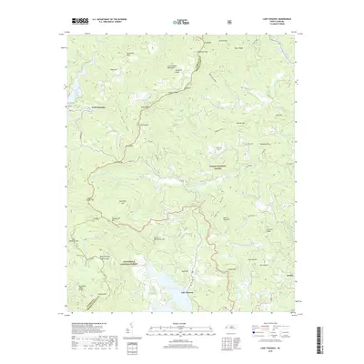
2019 Map of Lake Toxaway
USGS Topo · Published 2019About this map
The Tennessee Valley Divide snakes through this high-altitude landscape of Transylvania and Jackson Counties, where the headwaters of the W Fork French Broad River and N Fork French Broad River begin their descent. This terrain is defined by its massive peaks and ridges, including the prominent Toxaway Mtn and the sprawling Great Balsam Mountains. The map highlights the transition between the Pisgah National Forest and the Nantahala National Forest, showing a region dedicated largely to conservation and mountain recreation. At the heart of the valley, the large expanse of Lake Toxaway and the smaller Blue Ridge Lake provide significant water features amidst the forest. Local history is preserved in small mountain settlements like Quebec and Wolf Mountain, along with high-elevation family burial sites such as Owens Cem and McCall Cem, which offer physical links to the early residents of these steep ridges.
Find a feature on this map
89 named features on this map. Tap any name to fly to it.
Don’t see what you’re looking for? This feature index may not catch every label — zoom into the map to look around manually.
Map Details
Editions of this 2019 Lake Toxaway Map
This is the sole edition of this map. No revisions or reprints were ever made.
Other maps of this area

1891 · Cowee
USGS Topo · 1:125,000

1897 · Cowee
USGS Topo · 1:125,000

1905 · Pisgah
USGS Topo · 1:125,000

1906 · Pisgah
USGS Topo · 1:125,000

1907 · Cowee
USGS Topo · 1:125,000

1935 · Eastatoe Gap
USGS Topo · 1:24,000

1935 · Sam Knob
USGS Topo · 1:24,000

1935 · Cashiers
USGS Topo · 1:24,000

1935 · Rosman
USGS Topo · 1:24,000

1935 · Tuckaseigee
USGS Topo · 1:24,000