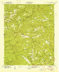
1947 Map of Lake Toxaway
USGS Topo · Published 1947About this map
Nantahala National Forest and Pisgah National Forest converge in this high-altitude landscape of the late 1940s. The terrain is defined by the Tenn Valley Divide and the headwaters of the Toxaway River, where the geography transitions from the steep slopes of Hogback Mountain and Big Pisgah Mtn to the mountain communities of Gloucester and Cañada. Unlike the modern developed lakefront, this era shows a series of dispersed settlements centered around remote schools and houses of worship. Small mountain schools like the Tennessee Gap Sch and Silverstein Sch served families in the isolated hollows of the Blue Ridge. The map documents the presence of family-linked landmarks and early mountain infrastructure, such as the Lookout Tower on Toxaway Mtn and the gathering points at Wolf Mountain Ch and Lake Toxaway Ch.
Find a feature on this map
96 named features on this map. Tap any name to fly to it.
Don’t see what you’re looking for? This feature index may not catch every label — zoom into the map to look around manually.
Map Details
Editions of this 1947 Lake Toxaway Map
This is the sole edition of this map. No revisions or reprints were ever made.
Other maps of this area

1891 · Cowee
USGS Topo · 1:125,000

1897 · Cowee
USGS Topo · 1:125,000

1905 · Pisgah
USGS Topo · 1:125,000

1906 · Pisgah
USGS Topo · 1:125,000

1907 · Cowee
USGS Topo · 1:125,000

1935 · Eastatoe Gap
USGS Topo · 1:24,000

1935 · Sam Knob
USGS Topo · 1:24,000

1935 · Cashiers
USGS Topo · 1:24,000

1935 · Rosman
USGS Topo · 1:24,000

1935 · Tuckaseigee
USGS Topo · 1:24,000