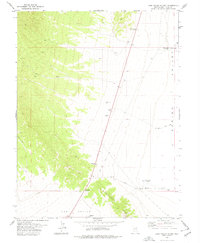
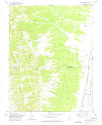
1978 Map of Lake Valley Summit
USGS Topo · Published 1978About this map
Lake Valley Summit serves as the topographic divide between the Great Basin's Lake Valley and Spring Valley in White Pine County. This 1970s landscape is defined by the vital presence of water in an arid environment, notably the North Fox Well and South Fox Well, which are identified as flowing artesian sources. The arid flats and slopes of the Fortification Range are crossed by a network of utilitarian transit routes, including the South Highline Road and numerous stretches of Jeep Trail. Local landmarks like Kirkeby Knoll provide reference points for travelers navigating the pass, where a designated Rest Area and various resource extraction sites such as a Gravel Pit and Borrow Pit mark the limited human footprint on this high-desert corridor.
Find a feature on this map
15 named features on this map. Tap any name to fly to it.
Don’t see what you’re looking for? This feature index may not catch every label — zoom into the map to look around manually.
Map Details
Editions of this 1978 Lake Valley Summit Map
This is the sole edition of this map. No revisions or reprints were ever made.
Other maps of this area

1948 · Wheeler Peak
USGS Topo · 1:62,500

1950 · Wheeler Peak
USGS Topo · 1:62,500

1956 · Lund
USGS Topo · 1:250,000

1960 · Lund
USGS Topo · 1:250,000

1973 · Indian Springs Knolls
USGS Topo · 1:24,000

1973 · Cattle Camp Spring
USGS Topo · 1:24,000
1973 · North Spring Point
USGS Topo · 1:24,000
1973 · Mount Grafton NE
USGS Topo · 1:24,000
1973 · Horse Camp Springs
USGS Topo · 1:24,000
1978 · Mt. Grafton
USGS Topo · 1:24,000