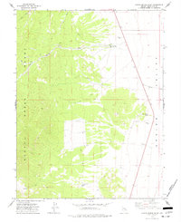
1973 Map of North Spring Point
USGS Topo · Published 1977About this map
Schell Creek Range slopes dramatically into the western margins of Spring Valley, defining a landscape where water management was central to life in the early 1970s. The map documents sparse but vital human infrastructure, including the John Henry Wash Well and a Water Tank near Dales Well. These points, connected by a network of Jeep Trails, highlight the reliance on isolated water sources for ranching or prospecting in this part of White Pine County.
Find a feature on this map
12 named features on this map. Tap any name to fly to it.
Don’t see what you’re looking for? This feature index may not catch every label — zoom into the map to look around manually.
Map Details
Editions of this 1973 North Spring Point Map
This is the sole edition of this map. No revisions or reprints were ever made.
Other maps of this area

1948 · Wheeler Peak
USGS Topo · 1:62,500

1950 · Wheeler Peak
USGS Topo · 1:62,500

1952 · Ely
USGS Topo · 1:125,000

1956 · Lund
USGS Topo · 1:250,000

1956 · Ely
USGS Topo · 1:250,000

1959 · Ely
USGS Topo · 1:250,000

1959 · Sacramento Pass
USGS Topo · 1:62,500

1959 · Connors Pass
USGS Topo · 1:62,500

1960 · Lund
USGS Topo · 1:250,000

1963 · Ely
USGS Topo · 1:250,000