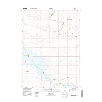
2013 Map of Lake Walcott East
USGS Topo · Published 2013About this map
Craters of the Moon National Preserve dominates the northern landscape of this region, where the volcanic expanse of the Wapi Flow meets the high desert of Cassia and Blaine Counties. The map documents a rugged intersection of historical transit and natural preservation, centered on the eastern reaches of Lake Walcott. The shoreline is punctuated by Bird Island and the freshwater outflow of Smith Springs, while the surrounding terrain is defined by basalt points like Brigham Point.
Find a feature on this map
18 named features on this map. Tap any name to fly to it.
Don’t see what you’re looking for? This feature index may not catch every label — zoom into the map to look around manually.
Map Details
Editions of this 2013 Lake Walcott East Map
This is the sole edition of this map. No revisions or reprints were ever made.
Other maps of this area

1954 · Pocatello
USGS Topo · 1:250,000

1958 · Pocatello
USGS Topo · 1:250,000

1959 · Lake Walcott
USGS Topo · 1:62,500

1959 · Yale
USGS Topo · 1:62,500

1972 · Schodde Well
USGS Topo · 1:24,000
1972 · Rattlesnake Butte
USGS Topo · 1:24,000

1972 · Minidoka
USGS Topo · 1:24,000
1984 · Gifford Spring
USGS Topo · 1:24,000

1984 · North Chapin Mountain
USGS Topo · 1:24,000
1984 · Lake Walcott West
USGS Topo · 1:24,000