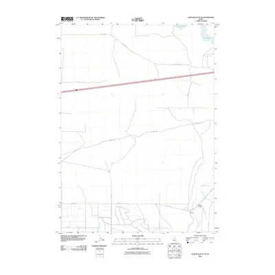
2010 Map of Lake Walcott SE
USGS Topo · Published 2010About this map
Emigrant Trl winds through this corner of Cassia County, marking a corridor of westward movement that predates the modern infrastructure of southern Idaho. The landscape is defined by the transition from the high desert terrain of Heglar Canyon toward the managed waters of Lake Walcott in the north. The Raft River flows through the southeastern portion of the quadrangle, where the agricultural footprint is anchored by the Lazy F C Ranch. The map reveals a grid of rural roads like N Yale Rd and Hisaw Ln that service the irrigation-dependent lands south of the interstate corridor. Transportation history is layered here, from the pioneer path of the Emigrant Trl to the legacy of Old Us Hwy 30, illustrating how topography and water access shaped the settlement of this Snake River Plain region.
Find a feature on this map
13 named features on this map. Tap any name to fly to it.
Don’t see what you’re looking for? This feature index may not catch every label — zoom into the map to look around manually.
Map Details
Editions of this 2010 Lake Walcott SE Map
This is the sole edition of this map. No revisions or reprints were ever made.
Other maps of this area

1954 · Pocatello
USGS Topo · 1:250,000

1958 · Pocatello
USGS Topo · 1:250,000

1958 · Sublett
USGS Topo · 1:62,500

1959 · Lake Walcott
USGS Topo · 1:62,500

1959 · Yale
USGS Topo · 1:62,500

1968 · Malta NE
USGS Topo · 1:24,000

1968 · Idahome
USGS Topo · 1:24,000
1984 · Gifford Spring
USGS Topo · 1:24,000

1984 · North Chapin Mountain
USGS Topo · 1:24,000
1984 · Lake Walcott West
USGS Topo · 1:24,000