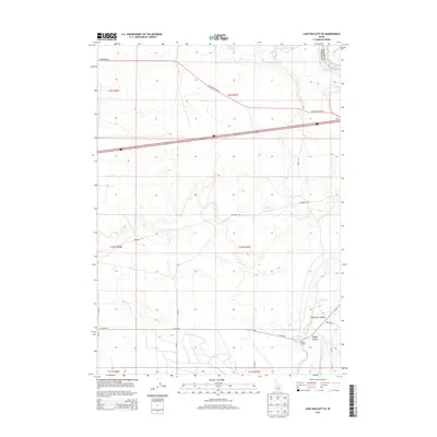
2013 Map of Lake Walcott SE
USGS Topo · Published 2013About this map
Lake Walcott and the winding Snake River define the northern reaches of this Idaho landscape, where the high desert meets the irrigated agricultural systems of the Snake River Plain. The historical Emigrant Trl cuts diagonally across the center of the sheet, providing a tangible link to the pioneer wagons that once traversed this corridor toward the Pacific. The terrain drops into the Raft River Valley in the southeast, where the Raft River flows out of Heglar Canyon. This area is characterized by a sparse settlement pattern typical of the region's ranching heritage, exemplified by the Lazy F C Ranch located near the canyon mouth. Modern transportation infrastructure like Old US Highway 30 and N Yale Rd follows the same natural pathways carved by earlier travelers, while local routes such as Hisaw Ln and Nellies Ln serve the contemporary homesteads scattered across the plains.
Find a feature on this map
26 named features on this map. Tap any name to fly to it.
Don’t see what you’re looking for? This feature index may not catch every label — zoom into the map to look around manually.
Map Details
Editions of this 2013 Lake Walcott SE Map
This is the sole edition of this map. No revisions or reprints were ever made.
Other maps of this area

1954 · Pocatello
USGS Topo · 1:250,000

1958 · Pocatello
USGS Topo · 1:250,000

1958 · Sublett
USGS Topo · 1:62,500

1959 · Lake Walcott
USGS Topo · 1:62,500

1959 · Yale
USGS Topo · 1:62,500

1968 · Malta NE
USGS Topo · 1:24,000

1968 · Idahome
USGS Topo · 1:24,000
1984 · Gifford Spring
USGS Topo · 1:24,000

1984 · North Chapin Mountain
USGS Topo · 1:24,000
1984 · Lake Walcott West
USGS Topo · 1:24,000