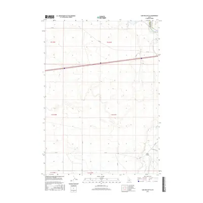
2017 Map of Lake Walcott SE
USGS Topo · Published 2017About this map
Lake Walcott and the winding course of the Raft River define this corner of southern Idaho near the border of Cassia and Blaine counties. This 2017 survey shows a landscape of agricultural sections and sagebrush terrain, bisected by the modern path of Interstate 86. The map provides a detailed view of local infrastructure, including family-named routes like Hegsaw Ln and the long stretches of Yale Rd and S Yale Rd. In the southeastern corner, the topography drops into Heglar Canyon, where Heglar Canyon Rd follows the natural drainage. This area illustrates the late 20th-century transition of the high desert through irrigation and the establishment of a robust county road network that supports the region's ranching and farming operations.
Find a feature on this map
20 named features on this map. Tap any name to fly to it.
Don’t see what you’re looking for? This feature index may not catch every label — zoom into the map to look around manually.
Map Details
Editions of this 2017 Lake Walcott SE Map
This is the sole edition of this map. No revisions or reprints were ever made.
Other maps of this area

1954 · Pocatello
USGS Topo · 1:250,000

1958 · Pocatello
USGS Topo · 1:250,000

1958 · Sublett
USGS Topo · 1:62,500

1959 · Lake Walcott
USGS Topo · 1:62,500

1959 · Yale
USGS Topo · 1:62,500

1968 · Malta NE
USGS Topo · 1:24,000

1968 · Idahome
USGS Topo · 1:24,000
1984 · Gifford Spring
USGS Topo · 1:24,000

1984 · North Chapin Mountain
USGS Topo · 1:24,000
1984 · Lake Walcott West
USGS Topo · 1:24,000