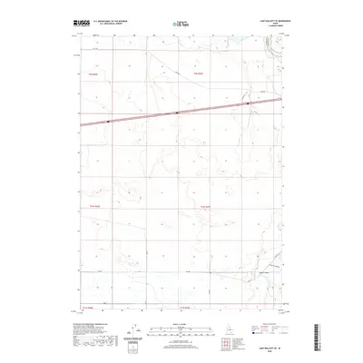
2020 Map of Lake Walcott SE
USGS Topo · Published 2020About this map
Raft River meanders through the southeastern portion of this Idaho landscape, carving a path near the mouth of Heglar Canyon. This high-desert terrain in Cassia County is defined by its rectilinear grid of township and range lines, intersected by the modern corridor of Interstate 86 and Highway 30. The map illustrates a transitional zone where the open range meets the more varied topography of the canyonlands. Local travel is marked by established routes like Yale Rd and Heglar Canyon Rd, which follow the natural contours of the drainage systems. The survey also captures the administrative boundary between Cassia and Blaine counties in the northeast corner, providing a clear view of how political borders were surveyed across this expansive topography. Researchers will find a landscape that remains primarily defined by large-scale land divisions and the vital watercourse of the river.
Find a feature on this map
23 named features on this map. Tap any name to fly to it.
Don’t see what you’re looking for? This feature index may not catch every label — zoom into the map to look around manually.
Map Details
Editions of this 2020 Lake Walcott SE Map
This is the sole edition of this map. No revisions or reprints were ever made.
Other maps of this area

1954 · Pocatello
USGS Topo · 1:250,000

1958 · Pocatello
USGS Topo · 1:250,000

1958 · Sublett
USGS Topo · 1:62,500

1959 · Lake Walcott
USGS Topo · 1:62,500

1959 · Yale
USGS Topo · 1:62,500

1968 · Malta NE
USGS Topo · 1:24,000

1968 · Idahome
USGS Topo · 1:24,000
1984 · Gifford Spring
USGS Topo · 1:24,000

1984 · North Chapin Mountain
USGS Topo · 1:24,000
1984 · Lake Walcott West
USGS Topo · 1:24,000